


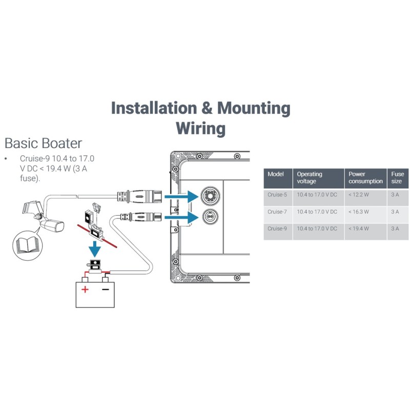


Cruise-5 ιντών βυθόμετρο. Περιλαμβάνει 83/200kHz transom mount transducer.
Simrad Cruise is the most intuitive, easy-to-use chartplotter available.
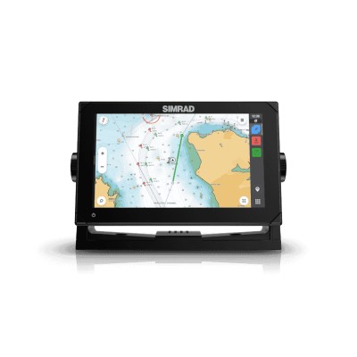
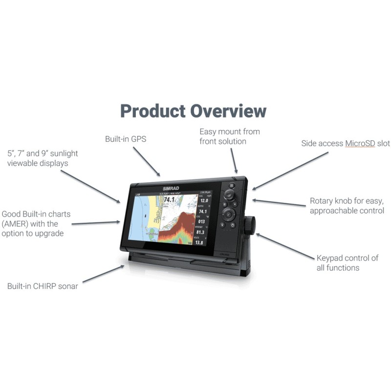
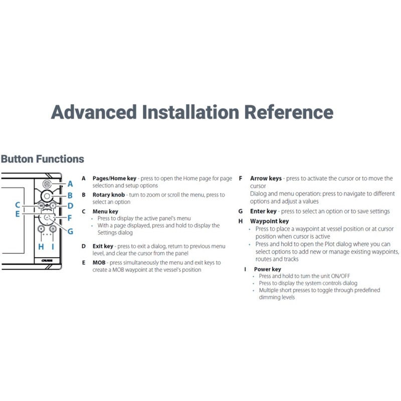
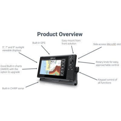
Everything you need for simple and straightforward GPS navigation is right inside the box – sunlight viewable display, mounting bracket and a sonar transducer. Simrad Cruise can display charts, navigation and sonar in split-screen view, or separately in full screen. Rotary dial and keypad controls make navigating through menus, creating routes and accessing temperature, speed, depth readings and battery voltage effortless.
Key Features
Smooth Navigation Between Menus
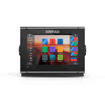
Simrad Cruise features intuitive menus, so you can quickly find the information you need, when you need it, and rotary dial and keypad controls make navigating from screen to screen effortless. Put away the instruction manual; with Simrad Cruise, you simply turn on your display and go!
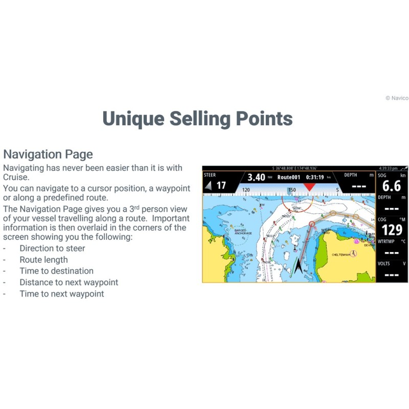
Always on course
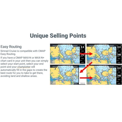
Know where you are and where you are going! Pre-loaded with basemaps, Simrad Cruise comes complete with all the charts you need to enjoy your day on the water. Want more detail? Choose from a wide range of enhanced charts from C-MAP® and Navionics®, and enjoy advanced features like C-MAP® Easy Routing for a true navigation experience.
Everything in view
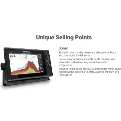
See the details you want the way you want them! Simrad Cruise offers both full and split-screen views, so you can easily display the information you need. Plotting your course? Select full screen charts for a maximum view of your surroundings. Not sure what’s underneath you? Choose full screen sonar for a clear view of the bottom and automatic depth tracking. Want to see it all? Use the split-screen option for the perfect combination of chart and sonar data.
Stay informed
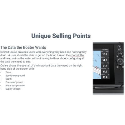
Simrad Cruise gives you access to the information you need for a safe and enjoyable time on the water. Depth readings, position, battery voltage and other critical boat information, can all be monitored on your screen for quick reference and situational awareness.
| Power Consumption | 5” = 12.2W, 7” = 16.3W, 9” = 19.4W |
| Colour | Black |
| Size | 5”, 7”, 9” Diagonal |
| Type | TFT Widescreen |
| Resolution | 800x480 |
| Illumination | 5” = 800 nits, 7/9” = 1000 nits |
| Viewing Angle | 80° top/bottom, 80° left/right of centre |
| Protection | IPx6 and IPx7 |
| Operating Temperature | -15°C to +55°C (+5°F to +131°F) |
| Operating Voltage | 12 V DC (10-17 V DC) |
| Storage | Micro SD Card 32GB Max (format FAT32) Unlimited if formatted NTFS |
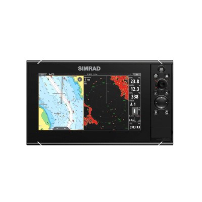
Το NSS9 evo3S είναι ένα MFD all-in-one, με ενσωματωμένο Sonar CHIRP διπλού καναλιού, GPS και WIFI. Υποστηρίζει τη χρήση χάρτη, radar, αυτόματου πιλότου, οργάνων κα.
NSX 3015UW, Έξυπνο πλόττερ / ανιχνευτής ψαριών. Υπερευρεία οθόνη υψηλής ευκρίνειας 15 ιντσών. Ενσωματωμένο ηχοσύστημα 1 kW, GPS και WIFI. Απαιτείται κάρτα γραφήματος C-MAP® DISCOVER™ X ή REVEAL X™. Χωρίς μορφοτροπέα.
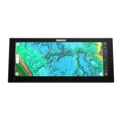
NSO evo3S 19" MFD Display Only - Πολυλειτουργική οθόνη all-in-one υψηλής απόδοσης. Με ενσωματωμένες μονάδες radar, αυτόματου πιλότου, sonar κ.α μέσω Ethernet και NMEA2000.
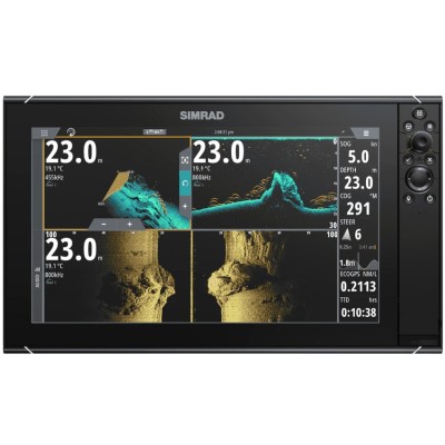
Το NSS12 evo3S είναι ένα MFD όλα σε ένα, με ενσωματωμένο σόναρ CHIRP δύο καναλιών, GPS και WIFI. Υποστήριξη για επιλογές χαρτών, ραντάρ, αυτόματο πιλότο, όργανα και πολλά άλλα.
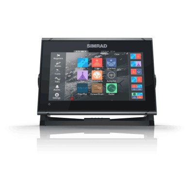
Το NSS16 evo3S είναι ένα MFD all-in-one, με ενσωματωμένο Sonar CHIRP διπλού καναλιού, GPS και WIFI. Υποστηρίζει τη χρήση χάρτη, radar, αυτόματου πιλότου, οργάνων κα.
Simrad GO7 XSR – Πολυλειτουργική οθόνη 7 ιντσών με ενσωματωμένο Echosounder, GPS και Wi-Fi. Εξαιρετικά φωτεινή οθόνη ευρείας οθόνης πολλαπλής αφής με NMEA 2000 και διασύνδεση Radar.
NSX 3009 - Οθόνη υψηλής ευκρίνειας SolarMAX™ 9 ιντσών, ενσωματωμένος ηχοήχων 1 kW, GPS και WIFI. Απαιτείται χάρτης C-MAP® DISCOVER™ X ή REVEAL X™ επόμενης γενιάς.
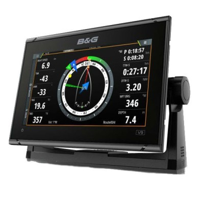
B&G Zeus S 9 Χαρτογράφος GLOBAL. Οθόνη SolarMAX™ υψηλής ευκρίνειας 9 ιντσών. Ενσωματωμένο GPS και WIFI, βυθόμετρο 1 kW. Μοναδικές λειτουργίες ιστιοπλοΐας και βελτιωμένα χαρακτηριστικά. Απαιτείται μια κάρτα χάρτη επόμενης γενιάς C-MAP® DISCOVER™ X ή REVEAL X™.
Simrad GO9 XSE – Πολυλειτουργική οθόνη 9 ιντσών με ενσωματωμένο Echosounder, GPS και Wi-Fi. Εξαιρετικά φωτεινή οθόνη ευρείας οθόνης πολλαπλής αφής με NMEA 2000 και διασύνδεση Radar.
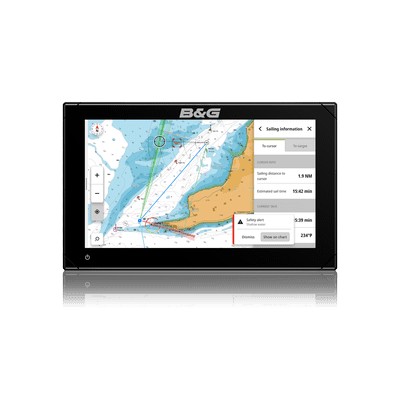
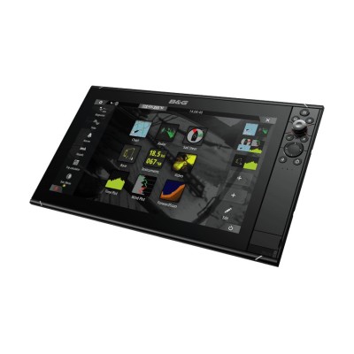
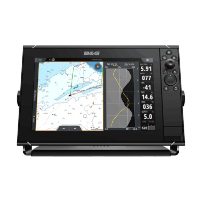
B&G Zeus³S-16, βυθόμετρο με ένα εύχρηστο σύστημα πλοήγησης χαρτογράφησης για bluewater και αγωνιστική regatta, με οθόνη αφής 16", ηλεκτρονικά υψηλής απόδοσης και ευρύ φάσμα λειτουργιών που έχουν σχεδιαστεί ειδικά για ναυσιπλοϊα. Περιέχει παγκόσμια χαρτογράφηση.
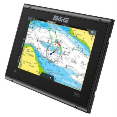
B&G Zeus S 7 Χαρτογράφος GLOBAL. Οθόνη SolarMAX™ υψηλής ευκρίνειας 7 ιντσών. Ενσωματωμένο GPS και WIFI, βυθόμετρο 1 kW. Μοναδικές λειτουργίες ιστιοπλοΐας και βελτιωμένα χαρακτηριστικά. Απαιτείται μια κάρτα χάρτη επόμενης γενιάς C-MAP® DISCOVER™ X ή REVEAL X™.
B&G Vulcan 9 FS: Πολυλειτουργική οθόνη 9". Έξτρα φωτεινή οθόνη πολλαπλής αφής με ενσωματωμένο NMEA2000, GPS, Wi-Fi και ForwardScan (προαιρετικά απαιτείται αισθητήρας). Ενσωματώνει το ραντάρ 3G / 4G. Δεν περιλαμβάνεται αισθητήρας. Παγκόσμια χαρτογράφηση.
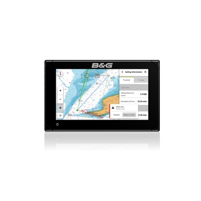
Το B&G Zeus³S-12 είναι ένα εύχρηστο σύστημα πλοήγησης με χαρτογράφο για κρουαζιερόπλοια και αγώνες ιστιοπλοΐας, το οποίο ενσωματώνει οθόνη αφής 12 ιντσών, ηλεκτρονικά συστήματα υψηλής απόδοσης και ένα ευρύ φάσμα λειτουργιών σχεδιασμένων ειδικά για ιστιοπλόους. Παγκόσμιοι χάρτες βάσης